|
D-21 thru D-23 |
|||
Property Description
|
|||
|
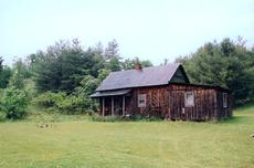
Directions From Galax, go 1.8 miles; turn right on Hwy 94 (Riverside Dr); go 8 miles and turn west on State Rte 805 (Spring Valley Rd); go 4.3 miles and turn right on State Rte 777 (Liberty Hill Rd); go 1.6 miles (bearing right at church-road name changes to Colonial Hills Rd) to a left on State Rte 653; go about 6 miles to the top of the mountain and turn left onto the lower driveway; property starts about 300 yards just past first gate; property will continue past second metal gate. NOTE: Small cabin just past second gate does not pass and will be removed by closing. All 3 tracts will get access by deeded right of way. NOTE: All 3 properties join the Virginia Highlands Trail and is adjacent to the Mount Rogers National recreation area. |
|||
 View Enlarged Map |
 View Enlarged Photo |
||
| Main Menu - General Info - Map - Aerial Photo - Property Photos | |||